Trail Road bike Aubagne - 
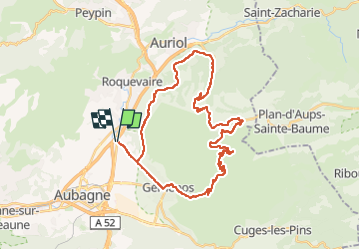
L' Espigoulier 723m D+900m - Photo
© OpenStreetMap contributors
Length
Length
39 km
Max alt
Max alt
744 m
Uphill gradient
Uphill gradient
909 m
Km-Effort
Km-Effort  
51 km
Min alt
Min alt
128 m
Downhill gradient
Downhill gradient
907 m
Boucle
Boucle
Yes
Creation date :
2023-05-06 14:59:05.322
Updated on :
2023-05-21 12:16:55.698

(0 Reviews)

Road bike
Road bike
3h05
Difficulty : Very difficult

Scan this QR Code to open this trail in the SityTrail application

FREE GPS app for hiking

Logo SityTrail SityTrail

IGN / Geographical institutes

Download SityTrail from the App Store Download SityTrail from Google Play

Logo SityTrail SityTrail Plus

The world is yours!

Download SityTrail from the App Store Download SityTrail from Google Play Download SityTrail on Huawei AppGallery

About

Trail Road bike of 39 km to be discovered at Provence-Alpes-Côte d'Azur, Bouches-du-Rhône, Aubagne. This trail is proposed by ericberlin.

Description

Pont de L'Etoile, Gemenos, L'espigoulier, Auriol, Roquevaire, Pont de L'Etoile

https://www.cols-cyclisme.com/sainte-baume-sainte-victoire/france/col-de-l-espigoulier-depuis-gemenos-c583.htm

Elevation profile

Photos

Positioning

Country:
France
Region :
Provence-Alpes-Côte d'Azur
Department/Province :
Bouches-du-Rhône
Municipality :
Aubagne
Location:
Unknown
Start:(UTM)
710355 ; 4799525 (31T) N.


Close
My subscriptions