


faverolles en berry

lecmic
User

Length
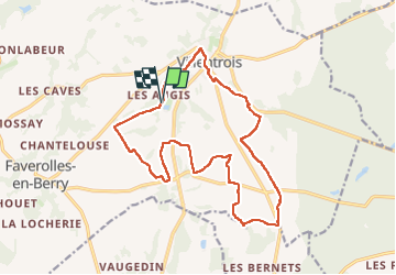
17.1 km

Max alt
147 m

Uphill gradient
192 m
Km-Effort
19.6 km

Min alt
91 m

Downhill gradient
193 m
Boucle
Yes
Creation date :
2023-05-07 05:19:04.787
Updated on :
2023-05-07 08:32:01.29
3h12
Difficulty : Easy

FREE GPS app for hiking
 SityTrail
IGN / Geographical institutes
SityTrail Plus
The world is yours!
About
Trail Walking of 17.1 km to be discovered at Centre-Loire Valley, Indre, Villentrois-Faverolles-en-Berry. This trail is proposed by lecmic.
Description
la planche
Positioning
Country:
France
Region :
Centre-Loire Valley
Department/Province :
Indre
Municipality :
Villentrois-Faverolles-en-Berry
Location:
Villentrois
Start:(Dec)
Start:(UTM)
382497 ; 5226994 (31T) N.
Comments