


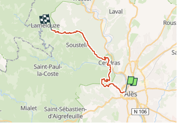
gard-cévennes j2

yvesconnes
User

Length
20 km

Max alt
599 m

Uphill gradient
778 m
Km-Effort
29 km

Min alt
129 m

Downhill gradient
429 m
Boucle
No
Creation date :
2023-05-07 08:51:24.715
Updated on :
2023-05-07 16:31:21.929
7h16
Difficulty : Difficult

FREE GPS app for hiking
 SityTrail
IGN / Geographical institutes
SityTrail Plus
The world is yours!
About
Trail Walking of 20 km to be discovered at Occitania, Gard, Alès. This trail is proposed by yvesconnes.
Positioning
Country:
France
Region :
Occitania
Department/Province :
Gard
Municipality :
Alès
Location:
Unknown
Start:(Dec)
Start:(UTM)
586250 ; 4886575 (31T) N.
Comments