


En passant par Dalibray

Fky78
User

Length
10.1 km

Max alt
125 m

Uphill gradient
204 m
Km-Effort
12.8 km

Min alt
31 m

Downhill gradient
201 m
Boucle
Yes
Creation date :
2023-05-07 15:14:49.609
Updated on :
2023-05-15 16:14:22.617
2h34
Difficulty : Difficult

FREE GPS app for hiking
 SityTrail
IGN / Geographical institutes
SityTrail Plus
The world is yours!
About
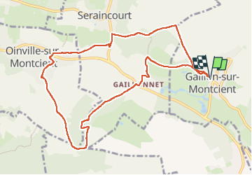
Trail Walking of 10.1 km to be discovered at Ile-de-France, Yvelines, Gaillon-sur-Montcient. This trail is proposed by Fky78.
Description
Boucle en partant de Gaillon sur Montcient
Photos


Positioning
Country:
France
Region :
Ile-de-France
Department/Province :
Yvelines
Municipality :
Gaillon-sur-Montcient
Location:
Unknown
Start:(Dec)
Start:(UTM)
418977 ; 5430841 (31U) N.
Comments