


Le Chatel ( Mens)

Evelyne et Francois
User
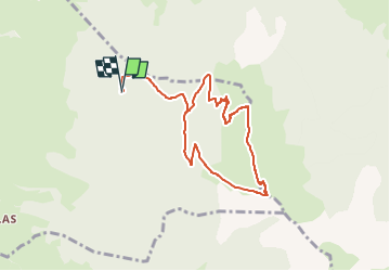

Length
8.3 km

Max alt
1933 m

Uphill gradient
656 m
Km-Effort
17 km

Min alt
1286 m

Downhill gradient
652 m
Boucle
Yes
Creation date :
2023-05-07 18:17:01.321
Updated on :
2023-05-07 18:17:02.983
3h51
Difficulty : Difficult

FREE GPS app for hiking
 SityTrail
IGN / Geographical institutes
SityTrail Plus
The world is yours!
About
Trail Walking of 8.3 km to be discovered at Auvergne-Rhône-Alpes, Isère, Mens. This trail is proposed by Evelyne et Francois.
Description
attention passage vertigineux avec main courante
Positioning
Country:
France
Region :
Auvergne-Rhône-Alpes
Department/Province :
Isère
Municipality :
Mens
Location:
Unknown
Start:(Dec)
Start:(UTM)
720644 ; 4966852 (31T) N.
Comments