


les collines0

ninia
User
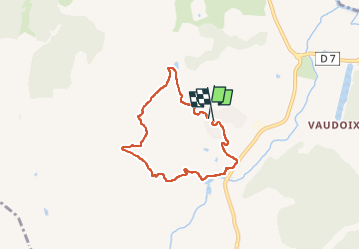

Length
6.1 km

Max alt
153 m

Uphill gradient
145 m
Km-Effort
8 km

Min alt
13 m

Downhill gradient
145 m
Boucle
Yes
Creation date :
2023-05-08 06:20:00.116
Updated on :
2023-05-08 08:29:55.187
2h09
Difficulty : Very easy

FREE GPS app for hiking
 SityTrail
IGN / Geographical institutes
SityTrail Plus
The world is yours!
About
Trail Walking of 6.1 km to be discovered at Provence-Alpes-Côte d'Azur, Var, Roquebrune-sur-Argens. This trail is proposed by ninia.
Positioning
Country:
France
Region :
Provence-Alpes-Côte d'Azur
Department/Province :
Var
Municipality :
Roquebrune-sur-Argens
Location:
Unknown
Start:(Dec)
Start:(UTM)
311456 ; 4808419 (32T) N.
Comments