Trail Walking Saint-Cergue - JURA 2023 J5 réel - Saint-Cergue à Morez - 24 360m +560m - Photo

JURA 2023 J5 réel - Saint-Cergue à Morez - 24 360m +560m

© OpenStreetMap contributors
Length
Length
24 km
Max alt
Max alt
1259 m
Uphill gradient
Uphill gradient
565 m
Km-Effort
Km-Effort  
33 km
Min alt
Min alt
705 m
Downhill gradient
Downhill gradient
904 m
Boucle
Boucle
No
Creation date :
2023-05-08 06:32:47.408
Updated on :
2023-05-10 07:23:00.122

(0 Reviews)

Walking
Walking
7h30
Difficulty : Very difficult

Scan this QR Code to open this trail in the SityTrail application

FREE GPS app for hiking

Logo SityTrail SityTrail

IGN / Geographical institutes

Download SityTrail from the App Store Download SityTrail from Google Play

Logo SityTrail SityTrail World

The world is yours!

Download SityTrail from the App Store Download SityTrail from Google Play Download SityTrail on Huawei AppGallery

About

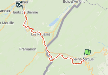
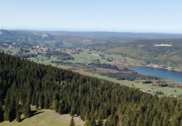
Trail Walking of 24 km to be discovered at Vaud, District de Nyon, Saint-Cergue. This trail is proposed by DanielROLLET.

Description

2023 05 08h30 à 16h30
Temps frais - Pluie en matinée
Pique-niqué dans la salle d'attente de la gare de la Cure
Bu un café aux Rousses
Circuit du Vieux Château à St Cergue aléatoire...
Erreur à la Dappe, pas vu l'entrée du sentier à la cote 1234
Clôture difficilement franchissable à l'entrée de la forêt entre Coupaloup-de Saint-Cergue et La Trélasse
Arrivé par le circuit de l'Archette la veille, donc reparti par le circuit du Vieux Château puis redescendu sur le GR5.
Parfois le tracé du GR5 n'est pas conforme à la carte   Tracé un peu spécial en Suisse.
Dormi à l'hôtel KYRIAD DIRECT
Transport bagages par taxis Grandval de St Laurent
Repris le train à 10h29 à Morez

Elevation profile

Positioning

Country:
Switzerland
Region :
Vaud
Department/Province :
District de Nyon
Municipality :
Saint-Cergue
Location:
Unknown
Start:(UTM)
281742 ; 5147580 (32T) N.

Trails nearby

Trail On foot Gingins - La Dôle - Photo
On foot
PRO

On foot

Easy
Gingins, Vaud, District de Nyon, Switzerland
8 km | 15.4 km-effort
3h 30min
Yes
Trail Walking Les Rousses - Noirmont et Creux du Croue - Photo
Walking
DanElise

Walking

Very easy
(1)
Les Rousses, Bourgogne-Franche-Comté, Jura, France
12.2 km | 19.8 km-effort
4h 18min
Yes
Trail Walking Chéserex - Tour de La Dole - Photo
Walking
tonymeyer

Walking

Easy
Chéserex, Vaud, District de Nyon, Switzerland
6.2 km | 9.8 km-effort
2h 4min
Yes
Trail Walking Saint-Cergue - Autour de la Givrine  - Photo
Walking
vazitonton

Walking

Easy
(1)
Saint-Cergue, Vaud, District de Nyon, Switzerland
10.2 km | 13.5 km-effort
4h 6min
Yes
Trail Walking Saint-Cergue - Col de la Givrine_La Dole - Photo
Walking
cmike39

Walking

Medium
(1)
Saint-Cergue, Vaud, District de Nyon, Switzerland
14.7 km | 23 km-effort
4h 48min
Yes
Trail Walking Saint-Cergue - CRÊT DES DANSES ET MONT PELÉ - Photo
Walking
Jean-Paulchoux

Walking

Medium
Saint-Cergue, Vaud, District de Nyon, Switzerland
17.3 km | 25 km-effort
6h 56min
Yes
Trail On foot La Rippe - Le Bauloz-Bonmont - Photo
On foot
PRO

On foot

Easy
La Rippe, Vaud, District de Nyon, Switzerland
3.7 km | 5.5 km-effort
1h 14min
No
Trail Other activity Bassins - y10_tobleroneweg - Photo
Other activity
GUIDE+

Other activity

Very easy
Bassins, Vaud, District de Nyon, Switzerland
23 km | 28 km-effort
5h 54min
No
Trail Walking Saint-Cergue - hike11 - Photo
Walking
GUIDE+

Walking

Very easy
Saint-Cergue, Vaud, District de Nyon, Switzerland
19.5 km | 30 km-effort
Unknown
No


Close
My subscriptions