


Gard cevennes J3

yvesconnes
User
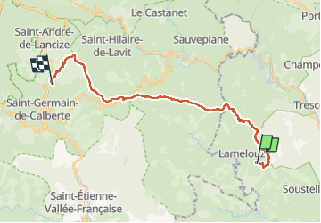

Length
25 km

Max alt
962 m

Uphill gradient
1004 m
Km-Effort
38 km

Min alt
433 m

Downhill gradient
996 m
Boucle
No
Creation date :
2023-05-08 06:54:49.727
Updated on :
2023-05-08 15:39:13.828
8h02
Difficulty : Difficult

FREE GPS app for hiking
 SityTrail
IGN / Geographical institutes
SityTrail Plus
The world is yours!
About
Trail Walking of 25 km to be discovered at Occitania, Gard, Lamelouze. This trail is proposed by yvesconnes.
Positioning
Country:
France
Region :
Occitania
Department/Province :
Gard
Municipality :
Lamelouze
Location:
Unknown
Start:(Dec)
Start:(UTM)
577912 ; 4893323 (31T) N.
Comments