


canyon des gueulards

veroberton
User
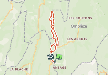

Length
14.1 km

Max alt
850 m

Uphill gradient
472 m
Km-Effort
20 km

Min alt
565 m

Downhill gradient
474 m
Boucle
Yes
Creation date :
2023-05-08 11:37:34.052
Updated on :
2023-05-08 16:04:07.006
4h25
Difficulty : Medium

FREE GPS app for hiking
 SityTrail
IGN / Geographical institutes
SityTrail Plus
The world is yours!
About
Trail Walking of 14.1 km to be discovered at Auvergne-Rhône-Alpes, Drôme, Omblèze. This trail is proposed by veroberton.
Positioning
Country:
France
Region :
Auvergne-Rhône-Alpes
Department/Province :
Drôme
Municipality :
Omblèze
Location:
Unknown
Start:(Dec)
Start:(UTM)
673335 ; 4966700 (31T) N.
Comments