


polder sommerly Erstein

apa
User
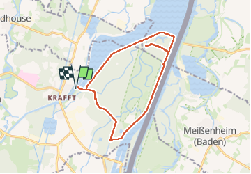

Length
14.5 km

Max alt
156 m

Uphill gradient
93 m
Km-Effort
15.7 km

Min alt
139 m

Downhill gradient
93 m
Boucle
Yes
Creation date :
2023-05-09 07:19:07.89
Updated on :
2023-05-09 11:36:15.139
4h03
Difficulty : Easy

FREE GPS app for hiking
 SityTrail
IGN / Geographical institutes
SityTrail Plus
The world is yours!
About
Trail Walking of 14.5 km to be discovered at Grand Est, Bas-Rhin, Erstein. This trail is proposed by apa.
Description
bucolique
Photos


Positioning
Country:
France
Region :
Grand Est
Department/Province :
Bas-Rhin
Municipality :
Erstein
Location:
Unknown
Start:(Dec)
Start:(UTM)
404390 ; 5364441 (32U) N.
Comments