


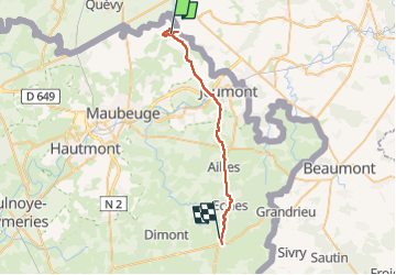
Départ Vilers Sire Nicole arrivée Solre Chateau

jeff2
User


6h50
Difficulty : Medium

FREE GPS app for hiking
 SityTrail
IGN / Geographical institutes
SityTrail Plus
The world is yours!
About
Trail Walking of 28 km to be discovered at Hauts-de-France, Nord, Villers-Sire-Nicole. This trail is proposed by jeff2.
Description
7 heures de marche, 7 Heures de pluie intense, arrêt à la Boulangerie de Marpent tenue par Rosa la péruvienne, très sympa offre le café.
Arrivée à Solre Château sous une pluie battante, la Mairie par son son secrétaire général nous ouvre les locaux sportifs de la ville.
Lessive, douche, tout va bien.
Photos


Positioning
Comments