


st Georges le bout du monde

chantde17
User
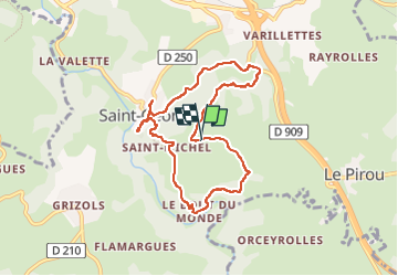

Length
8.3 km

Max alt
864 m

Uphill gradient
273 m
Km-Effort
11.9 km

Min alt
752 m

Downhill gradient
270 m
Boucle
Yes
Creation date :
2023-05-09 13:54:25.163
Updated on :
2023-05-09 16:38:41.206
2h15
Difficulty : Medium

FREE GPS app for hiking
 SityTrail
IGN / Geographical institutes
SityTrail Plus
The world is yours!
About
Trail Walking of 8.3 km to be discovered at Auvergne-Rhône-Alpes, Cantal, Saint-Georges. This trail is proposed by chantde17.
Positioning
Country:
France
Region :
Auvergne-Rhône-Alpes
Department/Province :
Cantal
Municipality :
Saint-Georges
Location:
Unknown
Start:(Dec)
Start:(UTM)
510698 ; 4984754 (31T) N.
Comments