


Bigonville 02-2023

collignpn
User GUIDE
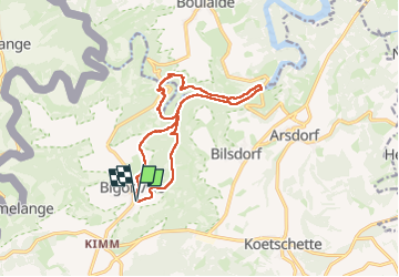

Length
12.7 km

Max alt
497 m

Uphill gradient
410 m
Km-Effort
18.2 km

Min alt
322 m

Downhill gradient
406 m
Boucle
Yes
Creation date :
2023-05-10 04:42:17.0
Updated on :
2023-05-11 07:12:18.628
4h07
Difficulty : Difficult

FREE GPS app for hiking
 SityTrail
IGN / Geographical institutes
SityTrail Plus
The world is yours!
About
Trail Walking of 12.7 km to be discovered at Unknown, Canton Redange, Rambrouch. This trail is proposed by collignpn.
Positioning
Country:
Luxembourg
Region :
Unknown
Department/Province :
Canton Redange
Municipality :
Rambrouch
Location:
Unknown
Start:(Dec)
Start:(UTM)
700842 ; 5525364 (31U) N.
Comments