


2014-11-25 Bondeval

bmorel@orange.fr
User
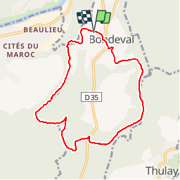

Length
8 km

Max alt
507 m

Uphill gradient
179 m
Km-Effort
10.4 km

Min alt
413 m

Downhill gradient
181 m
Boucle
Yes
Creation date :
2014-12-10 00:00:00.0
Updated on :
2014-12-10 00:00:00.0
2h21
Difficulty : Easy

FREE GPS app for hiking
 SityTrail
IGN / Geographical institutes
SityTrail Plus
The world is yours!
About
Trail Walking of 8 km to be discovered at Bourgogne-Franche-Comté, Doubs, Bondeval. This trail is proposed by bmorel@orange.fr.
Positioning
Country:
France
Region :
Bourgogne-Franche-Comté
Department/Province :
Doubs
Municipality :
Bondeval
Location:
Unknown
Start:(Dec)
Start:(UTM)
337535 ; 5256950 (32T) N.
Comments