


ferrieres des bois

Gmhlt5
User
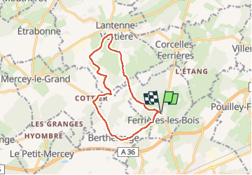

Length
12 km

Max alt
291 m

Uphill gradient
264 m
Km-Effort
15.5 km

Min alt
229 m

Downhill gradient
266 m
Boucle
Yes
Creation date :
2023-05-11 06:25:05.539
Updated on :
2023-05-11 09:38:14.261
3h12
Difficulty : Difficult

FREE GPS app for hiking
 SityTrail
IGN / Geographical institutes
SityTrail Plus
The world is yours!
About
Trail Walking of 12 km to be discovered at Bourgogne-Franche-Comté, Doubs, Ferrières-les-Bois. This trail is proposed by Gmhlt5.
Description
Randonnée
Positioning
Country:
France
Region :
Bourgogne-Franche-Comté
Department/Province :
Doubs
Municipality :
Ferrières-les-Bois
Location:
Unknown
Start:(Dec)
Start:(UTM)
712249 ; 5231776 (31T) N.
Comments