


Mouthe

taguette
User

Length
20 km

Max alt
1179 m

Uphill gradient
478 m
Km-Effort
26 km

Min alt
917 m

Downhill gradient
483 m
Boucle
No
Creation date :
2023-05-11 07:56:54.229
Updated on :
2023-05-11 13:01:44.188
5h00
Difficulty : Difficult

FREE GPS app for hiking
 SityTrail
IGN / Geographical institutes
SityTrail Plus
The world is yours!
About
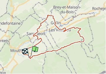
Trail Walking of 20 km to be discovered at Bourgogne-Franche-Comté, Doubs, Mouthe. This trail is proposed by taguette.
Positioning
Country:
France
Region :
Bourgogne-Franche-Comté
Department/Province :
Doubs
Municipality :
Mouthe
Location:
Unknown
Start:(Dec)
Start:(UTM)
286719 ; 5176422 (32T) N.
Comments