Hyères Le Chapeau de gendarme

Yot
User
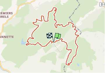

Length
14.2 km

Max alt
273 m

Uphill gradient
592 m
Km-Effort
22 km

Min alt
43 m

Downhill gradient
590 m
Boucle
Yes
Creation date :
2023-05-11 07:10:54.896
Updated on :
2023-05-11 14:31:00.312
6h24
Difficulty : Difficult

FREE GPS app for hiking
 SityTrail
IGN / Geographical institutes
SityTrail Plus
The world is yours!
About
Trail Walking of 14.2 km to be discovered at Provence-Alpes-Côte d'Azur, Var, Hyères. This trail is proposed by Yot.
Positioning
Country:
France
Region :
Provence-Alpes-Côte d'Azur
Department/Province :
Var
Municipality :
Hyères
Location:
Unknown
Start:(Dec)
Start:(UTM)
271387 ; 4780852 (32T) N.
Comments