


Belgentier arche de la Garoute les ragages

chrifor
User

Length
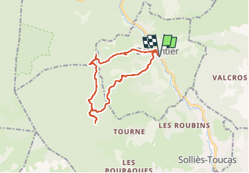
13.9 km

Max alt
625 m

Uphill gradient
588 m
Km-Effort
22 km

Min alt
152 m

Downhill gradient
587 m
Boucle
Yes
Creation date :
2023-05-11 07:32:48.674
Updated on :
2023-05-11 15:51:47.195
5h00
Difficulty : Medium

FREE GPS app for hiking
 SityTrail
IGN / Geographical institutes
SityTrail Plus
The world is yours!
About
Trail Walking of 13.9 km to be discovered at Provence-Alpes-Côte d'Azur, Var, Belgentier. This trail is proposed by chrifor.
Photos


Positioning
Country:
France
Region :
Provence-Alpes-Côte d'Azur
Department/Province :
Var
Municipality :
Belgentier
Location:
Unknown
Start:(Dec)
Start:(UTM)
256562 ; 4792177 (32T) N.
Comments