


Boulogne Wimereux 11Mai2023

tenace
User
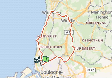

Length
14.3 km

Max alt
94 m

Uphill gradient
166 m
Km-Effort
16.5 km

Min alt
3 m

Downhill gradient
166 m
Boucle
Yes
Creation date :
2023-05-11 12:37:48.517
Updated on :
2023-05-11 16:06:05.741
2h55
Difficulty : Difficult

FREE GPS app for hiking
 SityTrail
IGN / Geographical institutes
SityTrail Plus
The world is yours!
About
Trail Walking of 14.3 km to be discovered at Hauts-de-France, Pas-de-Calais, Boulogne-sur-Mer. This trail is proposed by tenace.
Positioning
Country:
France
Region :
Hauts-de-France
Department/Province :
Pas-de-Calais
Municipality :
Boulogne-sur-Mer
Location:
Unknown
Start:(Dec)
Start:(UTM)
401255 ; 5620958 (31U) N.
Comments