


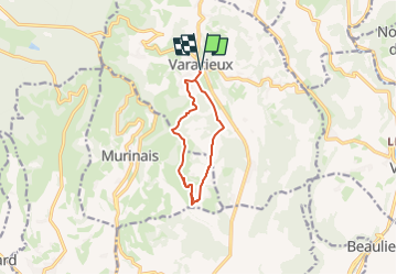
Le (petit) Travers du Pin

raymondfn
User

Length
9.2 km

Max alt
584 m

Uphill gradient
283 m
Km-Effort
13 km

Min alt
372 m

Downhill gradient
283 m
Boucle
Yes
Creation date :
2023-05-13 08:00:26.335
Updated on :
2023-05-14 13:11:23.858
2h57
Difficulty : Difficult

FREE GPS app for hiking
 SityTrail
IGN / Geographical institutes
SityTrail Plus
The world is yours!
About
Trail Walking of 9.2 km to be discovered at Auvergne-Rhône-Alpes, Isère, Varacieux. This trail is proposed by raymondfn.
Positioning
Country:
France
Region :
Auvergne-Rhône-Alpes
Department/Province :
Isère
Municipality :
Varacieux
Location:
Unknown
Start:(Dec)
Start:(UTM)
683478 ; 5011321 (31T) N.
Comments