


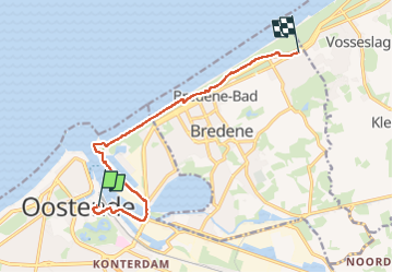
Ostende - Bredene

mumu.larandonneuse
User GUIDE

Length
9.4 km

Max alt
25 m

Uphill gradient
66 m
Km-Effort
10.3 km

Min alt
-4 m

Downhill gradient
68 m
Boucle
No
Creation date :
2023-05-13 09:47:42.758
Updated on :
2023-05-14 20:35:54.514
1h41
Difficulty : Easy

FREE GPS app for hiking
 SityTrail
IGN / Geographical institutes
SityTrail Plus
The world is yours!
About
Trail Walking of 9.4 km to be discovered at Flanders, West Flanders, Ostend. This trail is proposed by mumu.larandonneuse.
Description
Une partie du parcours des 80 kms de l'AG Belgian Coast Walk 2023.
Photos


Positioning
Country:
Belgium
Region :
Flanders
Department/Province :
West Flanders
Municipality :
Ostend
Location:
Oostende
Start:(Dec)
Start:(UTM)
494829 ; 5674964 (31U) N.
Comments