


Fontaine Rully

XavierFaidix
User
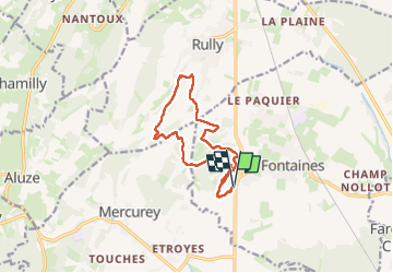

Length
11.8 km

Max alt
315 m

Uphill gradient
241 m
Km-Effort
15 km

Min alt
217 m

Downhill gradient
241 m
Boucle
Yes
Creation date :
2023-05-13 13:18:46.543
Updated on :
2023-05-13 16:55:14.581
2h30
Difficulty : Easy

FREE GPS app for hiking
 SityTrail
IGN / Geographical institutes
SityTrail Plus
The world is yours!
About
Trail Walking of 11.8 km to be discovered at Bourgogne-Franche-Comté, Saône-et-Loire, Fontaines. This trail is proposed by XavierFaidix.
Positioning
Country:
France
Region :
Bourgogne-Franche-Comté
Department/Province :
Saône-et-Loire
Municipality :
Fontaines
Location:
Unknown
Start:(Dec)
Start:(UTM)
633556 ; 5189425 (31T) N.
Comments