


montlaur

lablaquiere
User
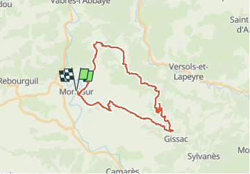

Length
33 km

Max alt
787 m

Uphill gradient
827 m
Km-Effort
44 km

Min alt
338 m

Downhill gradient
829 m
Boucle
Yes
Creation date :
2023-05-14 07:14:04.684
Updated on :
2023-05-14 11:10:44.502
2h42
Difficulty : Very difficult

FREE GPS app for hiking
 SityTrail
IGN / Geographical institutes
SityTrail Plus
The world is yours!
About
Trail Mountain bike of 33 km to be discovered at Occitania, Aveyron, Montlaur. This trail is proposed by lablaquiere.
Positioning
Country:
France
Region :
Occitania
Department/Province :
Aveyron
Municipality :
Montlaur
Location:
Unknown
Start:(Dec)
Start:(UTM)
486673 ; 4858600 (31T) N.
Comments