


Vercors Crêtes du Baconnet

c.gourme
User
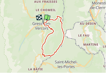

Length
13.1 km

Max alt
1796 m

Uphill gradient
792 m
Km-Effort
24 km

Min alt
1187 m

Downhill gradient
794 m
Boucle
Yes
Creation date :
2023-05-14 07:09:56.0
Updated on :
2023-05-21 19:08:36.902
5h11
Difficulty : Medium

FREE GPS app for hiking
 SityTrail
IGN / Geographical institutes
SityTrail Plus
The world is yours!
About
Trail Walking of 13.1 km to be discovered at Auvergne-Rhône-Alpes, Isère, Gresse-en-Vercors. This trail is proposed by c.gourme.
Description
On traverse beaucoup de champs : à faire qd il n'y a pas d'animaux ds les champs
Positioning
Country:
France
Region :
Auvergne-Rhône-Alpes
Department/Province :
Isère
Municipality :
Gresse-en-Vercors
Location:
Unknown
Start:(Dec)
Start:(UTM)
702764 ; 4975317 (31T) N.
Comments