


Reconnaissance Roche Tuilière et Sanadoire

Chabard
User
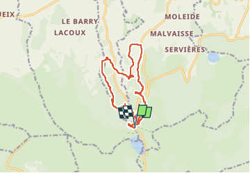

Length
14.5 km

Max alt
1283 m

Uphill gradient
535 m
Km-Effort
22 km

Min alt
994 m

Downhill gradient
535 m
Boucle
Yes
Creation date :
2023-05-14 08:24:15.0
Updated on :
2023-05-14 13:03:11.094
4h38
Difficulty : Medium

FREE GPS app for hiking
 SityTrail
IGN / Geographical institutes
SityTrail Plus
The world is yours!
About
Trail Walking of 14.5 km to be discovered at Auvergne-Rhône-Alpes, Puy-de-Dôme, Orcival. This trail is proposed by Chabard.
Description
Reconnaissance Roche Tuilière et Sanadoire
Positioning
Country:
France
Region :
Auvergne-Rhône-Alpes
Department/Province :
Puy-de-Dôme
Municipality :
Orcival
Location:
Unknown
Start:(Dec)
Start:(UTM)
486011 ; 5052029 (31T) N.
Comments