


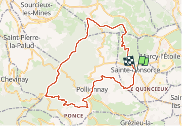
Sainte- Consorce (20 km - D. 630 m)

Thomasdanielle
User

Length
20 km

Max alt
734 m

Uphill gradient
632 m
Km-Effort
29 km

Min alt
328 m

Downhill gradient
631 m
Boucle
Yes
Creation date :
2023-05-15 07:35:26.0
Updated on :
2023-05-16 16:04:06.179
6h29
Difficulty : Very difficult

FREE GPS app for hiking
 SityTrail
IGN / Geographical institutes
SityTrail Plus
The world is yours!
About
Trail Walking of 20 km to be discovered at Auvergne-Rhône-Alpes, Rhône, Sainte-Consorce. This trail is proposed by Thomasdanielle.
Description
D/A Parking proche de l'église - Rue des Monts.
Positioning
Country:
France
Region :
Auvergne-Rhône-Alpes
Department/Province :
Rhône
Municipality :
Sainte-Consorce
Location:
Unknown
Start:(Dec)
Start:(UTM)
631461 ; 5070350 (31T) N.
Comments