


Cantal 9ème jour

rlebasque
User
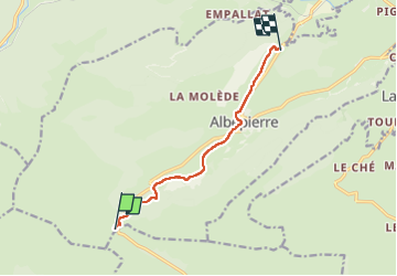

Length
7.4 km

Max alt
1391 m

Uphill gradient
22 m
Km-Effort
9 km

Min alt
996 m

Downhill gradient
413 m
Boucle
No
Creation date :
2023-05-16 06:04:48.909
Updated on :
2023-05-16 08:02:08.939
1h56
Difficulty : Medium

FREE GPS app for hiking
 SityTrail
IGN / Geographical institutes
SityTrail Plus
The world is yours!
About
Trail Walking of 7.4 km to be discovered at Auvergne-Rhône-Alpes, Cantal, Albepierre-Bredons. This trail is proposed by rlebasque.
Positioning
Country:
France
Region :
Auvergne-Rhône-Alpes
Department/Province :
Cantal
Municipality :
Albepierre-Bredons
Location:
Unknown
Start:(Dec)
Start:(UTM)
483719 ; 4988811 (31T) N.
Comments