Trail Nordic walking Embrun - Belvédère de la Para par sentier des Fontainier boucle N 1 courte - Photo

Belvédère de la Para par sentier des Fontainier boucle N 1 courte

 damlou
damlou

User

© OpenStreetMap contributors
Length
Length
6.7 km
Max alt
Max alt
1868 m
Uphill gradient
Uphill gradient
292 m
Km-Effort
Km-Effort  
10.5 km
Min alt
Min alt
1592 m
Downhill gradient
Downhill gradient
292 m
Boucle
Boucle
Yes
Creation date :
2023-05-16 07:42:50.354
Updated on :
2023-05-16 10:16:12.213

(0 Reviews)

Nordic walking
Nordic walking
1h59
Difficulty : Very easy

Scan this QR Code to open this trail in the SityTrail application

FREE GPS app for hiking

Logo SityTrail SityTrail

IGN / Geographical institutes

Download SityTrail from the App Store Download SityTrail from Google Play

Logo SityTrail SityTrail Plus

The world is yours!

Download SityTrail from the App Store Download SityTrail from Google Play Download SityTrail on Huawei AppGallery

About

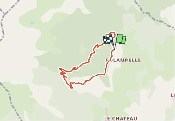
Trail Nordic walking of 6.7 km to be discovered at Provence-Alpes-Côte d'Azur, Hautes-Alpes, Embrun. This trail is proposed by damlou.

Description

Départ parking mon Guillaume
Tout droit vers Fontainiers
chapelle de Seyière.
prendre à droite panneau par terre
Arriver route citerne prendre à gauche vers la Para
Ici nous avons été à droite
A la Para demi-tour
Retour parking

Elevation profile

Positioning

Country:
France
Region :
Provence-Alpes-Côte d'Azur
Department/Province :
Hautes-Alpes
Municipality :
Embrun
Location:
Unknown
Start:(UTM)
299621 ; 4940893 (32T) N.

Comments

Please log in to post a review or rate the element


Livre Guillaine P77 boucle longue couper à gauche au point 4 descendre à la citerne à droite vers la Para puis faire demi-tour vers le parking


Close
My subscriptions