


château double

vincente204
User
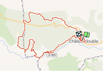

Length
15.5 km

Max alt
649 m

Uphill gradient
490 m
Km-Effort
22 km

Min alt
286 m

Downhill gradient
482 m
Boucle
Yes
Creation date :
2023-05-16 06:37:47.408
Updated on :
2023-05-16 12:55:21.364
6h16
Difficulty : Very difficult

FREE GPS app for hiking
 SityTrail
IGN / Geographical institutes
SityTrail Plus
The world is yours!
About
Trail Walking of 15.5 km to be discovered at Provence-Alpes-Côte d'Azur, Var, Châteaudouble. This trail is proposed by vincente204.
Description
difficile
Positioning
Country:
France
Region :
Provence-Alpes-Côte d'Azur
Department/Province :
Var
Municipality :
Châteaudouble
Location:
Unknown
Start:(Dec)
Start:(UTM)
294208 ; 4830224 (32T) N.
Comments