


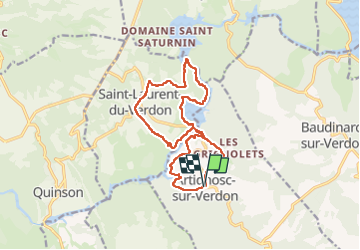
Artignosc Chemin de l'eau

aljac
User

Length
16 km

Max alt
510 m

Uphill gradient
324 m
Km-Effort
20 km

Min alt
401 m

Downhill gradient
320 m
Boucle
Yes
Creation date :
2023-05-16 07:32:28.763
Updated on :
2023-05-16 13:19:03.976
4h02
Difficulty : Easy

FREE GPS app for hiking
 SityTrail
IGN / Geographical institutes
SityTrail Plus
The world is yours!
About
Trail Walking of 16 km to be discovered at Provence-Alpes-Côte d'Azur, Var, Artignosc-sur-Verdon. This trail is proposed by aljac.
Positioning
Country:
France
Region :
Provence-Alpes-Côte d'Azur
Department/Province :
Var
Municipality :
Artignosc-sur-Verdon
Location:
Unknown
Start:(Dec)
Start:(UTM)
265547 ; 4843038 (32T) N.
Comments