


Reconnaissance fontaine Salée

Chabard
User
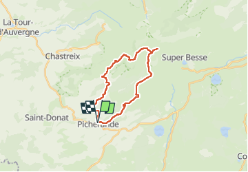

Length
24 km

Max alt
1686 m

Uphill gradient
736 m
Km-Effort
33 km

Min alt
1101 m

Downhill gradient
736 m
Boucle
Yes
Creation date :
2023-05-17 07:24:21.0
Updated on :
2023-05-17 13:48:27.739
6h23
Difficulty : Very difficult

FREE GPS app for hiking
 SityTrail
IGN / Geographical institutes
SityTrail Plus
The world is yours!
About
Trail Walking of 24 km to be discovered at Auvergne-Rhône-Alpes, Puy-de-Dôme, Picherande. This trail is proposed by Chabard.
Description
Reconnaissance fontaine Salée
Positioning
Country:
France
Region :
Auvergne-Rhône-Alpes
Department/Province :
Puy-de-Dôme
Municipality :
Picherande
Location:
Unknown
Start:(Dec)
Start:(UTM)
482016 ; 5034678 (31T) N.
Comments