


Compiègne

Pachinou
User
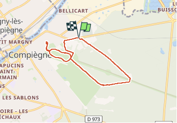

Length
6.6 km

Max alt
65 m

Uphill gradient
79 m
Km-Effort
7.7 km

Min alt
36 m

Downhill gradient
80 m
Boucle
Yes
Creation date :
2023-05-17 12:08:09.992
Updated on :
2023-05-17 14:13:32.785
2h04
Difficulty : Medium

FREE GPS app for hiking
 SityTrail
IGN / Geographical institutes
SityTrail Plus
The world is yours!
About
Trail Walking of 6.6 km to be discovered at Hauts-de-France, Oise, Compiègne. This trail is proposed by Pachinou.
Positioning
Country:
France
Region :
Hauts-de-France
Department/Province :
Oise
Municipality :
Compiègne
Location:
Unknown
Start:(Dec)
Start:(UTM)
488633 ; 5474343 (31U) N.
Comments