


Gif

pmauvieux
User
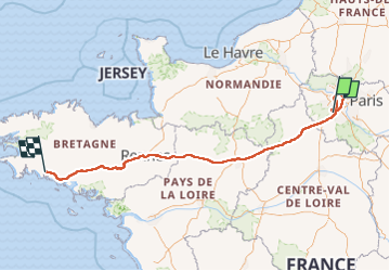

Length
659 km

Max alt
248 m

Uphill gradient
6168 m
Km-Effort
742 km

Min alt
0 m

Downhill gradient
6160 m
Boucle
No
Creation date :
2023-05-14 07:43:51.954
Updated on :
2023-05-17 14:42:48.791
13h14
Difficulty : Medium

FREE GPS app for hiking
 SityTrail
IGN / Geographical institutes
SityTrail Plus
The world is yours!
About
Trail Walking of 659 km to be discovered at Ile-de-France, Essonne, Gif-sur-Yvette. This trail is proposed by pmauvieux.
Positioning
Country:
France
Region :
Ile-de-France
Department/Province :
Essonne
Municipality :
Gif-sur-Yvette
Location:
Unknown
Start:(Dec)
Start:(UTM)
436416 ; 5394275 (31U) N.
Comments