


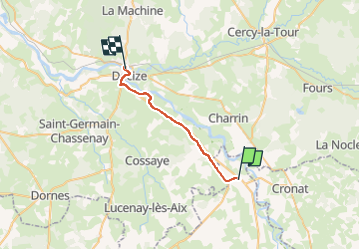
GR3 Alt. Gannay to Declize

Shadowfax
User

Length
21 km

Max alt
205 m

Uphill gradient
88 m
Km-Effort
22 km

Min alt
187 m

Downhill gradient
100 m
Boucle
No
Creation date :
2023-05-18 06:41:55.0
Updated on :
2023-05-18 06:41:56.605
0m
Difficulty : Unknown

FREE GPS app for hiking
 SityTrail
IGN / Geographical institutes
SityTrail Plus
The world is yours!
About
Trail Trail of 21 km to be discovered at Auvergne-Rhône-Alpes, Allier, Gannay-sur-Loire. This trail is proposed by Shadowfax.
Positioning
Country:
France
Region :
Auvergne-Rhône-Alpes
Department/Province :
Allier
Municipality :
Gannay-sur-Loire
Location:
Unknown
Start:(Dec)
Start:(UTM)
546811 ; 5175414 (31T) N.
Comments