


Roesbrugge

JanDeprez
User

Length
19.8 km

Max alt
18 m

Uphill gradient
73 m
Km-Effort
21 km

Min alt
-1 m

Downhill gradient
72 m
Boucle
Yes
Creation date :
2014-12-10 00:00:00.0
Updated on :
2014-12-10 00:00:00.0
4h00
Difficulty : Unknown

FREE GPS app for hiking
 SityTrail
IGN / Geographical institutes
SityTrail Plus
The world is yours!
About
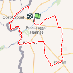
Trail Walking of 19.8 km to be discovered at Flanders, West Flanders, Poperinge. This trail is proposed by JanDeprez.
Description
Wandeltocht rond Roesbrugge, langs IJzer, grens, naar Haringz, Proven en terug
Positioning
Country:
Belgium
Region :
Flanders
Department/Province :
West Flanders
Municipality :
Poperinge
Location:
Roesbrugge-Haringe
Start:(Dec)
Start:(UTM)
473476 ; 5641041 (31U) N.
Comments