


toertje rond

David Cauchie
User
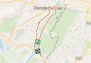

Length
3 km

Max alt
17 m

Uphill gradient
14 m
Km-Effort
3.2 km

Min alt
5 m

Downhill gradient
16 m
Boucle
No
Creation date :
2023-05-18 10:12:40.648
Updated on :
2023-05-18 10:55:57.455
43m
Difficulty : Easy

FREE GPS app for hiking
 SityTrail
IGN / Geographical institutes
SityTrail Plus
The world is yours!
About
Trail Walking of 3 km to be discovered at Flanders, East Flanders, Denderleeuw. This trail is proposed by David Cauchie.
Description
langs de Dender
Positioning
Country:
Belgium
Region :
Flanders
Department/Province :
East Flanders
Municipality :
Denderleeuw
Location:
Denderleeuw
Start:(Dec)
Start:(UTM)
575782 ; 5636472 (31U) N.
Comments