


jj

craninxluc
User
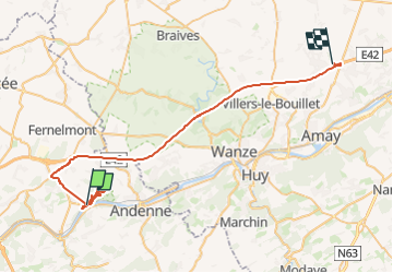

Length
45 km

Max alt
213 m

Uphill gradient
664 m
Km-Effort
54 km

Min alt
68 m

Downhill gradient
607 m
Boucle
No
Creation date :
2023-04-29 07:55:45.441
Updated on :
2023-05-18 11:08:33.662
6h40
Difficulty : Very difficult

FREE GPS app for hiking
 SityTrail
IGN / Geographical institutes
SityTrail Plus
The world is yours!
About
Trail Walking of 45 km to be discovered at Wallonia, Namur, Andenne. This trail is proposed by craninxluc.
Description
frt
Positioning
Country:
Belgium
Region :
Wallonia
Department/Province :
Namur
Municipality :
Andenne
Location:
Unknown
Start:(Dec)
Start:(UTM)
643913 ; 5595543 (31U) N.
Comments