


St Romain

cmike39
User
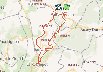

Length
19.4 km

Max alt
543 m

Uphill gradient
712 m
Km-Effort
29 km

Min alt
324 m

Downhill gradient
714 m
Boucle
Yes
Creation date :
2023-05-18 07:15:52.831
Updated on :
2023-05-18 14:01:21.178
5h06
Difficulty : Very difficult

FREE GPS app for hiking
 SityTrail
IGN / Geographical institutes
SityTrail Plus
The world is yours!
About
Trail Walking of 19.4 km to be discovered at Bourgogne-Franche-Comté, Côte-d'Or, Saint-Romain. This trail is proposed by cmike39.
Positioning
Country:
France
Region :
Bourgogne-Franche-Comté
Department/Province :
Côte-d'Or
Municipality :
Saint-Romain
Location:
Unknown
Start:(Dec)
Start:(UTM)
629919 ; 5206478 (31T) N.
Comments