Trail Mountain bike Ban-sur-Meurthe-Clefcy - BALVEURCHE - Photo
© OpenStreetMap contributors
Length
Length
30 km
Max alt
Max alt
1098 m
Uphill gradient
Uphill gradient
671 m
Km-Effort
Km-Effort  
39 km
Min alt
Min alt
809 m
Downhill gradient
Downhill gradient
670 m
Boucle
Boucle
Yes
Creation date :
2023-05-18 12:05:06.285
Updated on :
2023-05-18 15:28:46.971

(0 Reviews)

Mountain bike
Mountain bike
2h55
Difficulty : Medium

Scan this QR Code to open this trail in the SityTrail application

FREE GPS app for hiking

Logo SityTrail SityTrail

IGN / Geographical institutes

Download SityTrail from the App Store Download SityTrail from Google Play

Logo SityTrail SityTrail Plus

The world is yours!

Download SityTrail from the App Store Download SityTrail from Google Play Download SityTrail on Huawei AppGallery

About

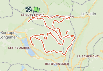
Trail Mountain bike of 30 km to be discovered at Grand Est, Vosges, Ban-sur-Meurthe-Clefcy. This trail is proposed by surceneux.

Description

SURCENEUX GRD VALTIN CHEMIN GRANGE SIMON IRENEE DUVOID COL 3 PLACES ANCIENNE FONTAINE DUCS BALVEURCHE AR BALVEURCHE CHEMIN INGOLD ROCHE BOULARD AR BELBRIETTE TOUR PORT DES PLANCHES SURCENEUX PAR CHEMIN GASPARD

Elevation profile

Positioning

Country:
France
Region :
Grand Est
Department/Province :
Vosges
Municipality :
Ban-sur-Meurthe-Clefcy
Location:
Unknown
Start:(UTM)
347849 ; 5329044 (32U) N.


Close
My subscriptions