


la montagne de Saillans

reneperrin
User
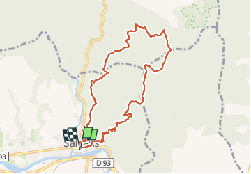

Length
9.4 km

Max alt
785 m

Uphill gradient
542 m
Km-Effort
16.7 km

Min alt
268 m

Downhill gradient
544 m
Boucle
Yes
Creation date :
2023-05-18 13:17:46.159
Updated on :
2023-05-18 15:55:26.888
2h29
Difficulty : Medium

FREE GPS app for hiking
 SityTrail
IGN / Geographical institutes
SityTrail Plus
The world is yours!
About
Trail Walking of 9.4 km to be discovered at Auvergne-Rhône-Alpes, Drôme, Saillans. This trail is proposed by reneperrin.
Description
boucle
Positioning
Country:
France
Region :
Auvergne-Rhône-Alpes
Department/Province :
Drôme
Municipality :
Saillans
Location:
Unknown
Start:(Dec)
Start:(UTM)
674082 ; 4951582 (31T) N.
Comments