


lanchare/BRancion

mcterret
User
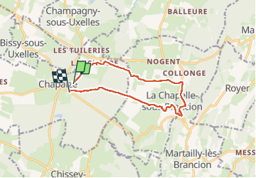

Length
12.3 km

Max alt
373 m

Uphill gradient
297 m
Km-Effort
16.3 km

Min alt
205 m

Downhill gradient
296 m
Boucle
No
Creation date :
2023-05-03 13:06:41.729
Updated on :
2023-05-19 07:29:57.412
3h09
Difficulty : Medium

FREE GPS app for hiking
 SityTrail
IGN / Geographical institutes
SityTrail Plus
The world is yours!
About
Trail Walking of 12.3 km to be discovered at Bourgogne-Franche-Comté, Saône-et-Loire, Chapaize. This trail is proposed by mcterret.
Positioning
Country:
France
Region :
Bourgogne-Franche-Comté
Department/Province :
Saône-et-Loire
Municipality :
Chapaize
Location:
Unknown
Start:(Dec)
Start:(UTM)
633702 ; 5157420 (31T) N.
Comments