


LAGORCE

nordan
User
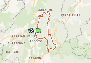

Length
16.4 km

Max alt
290 m

Uphill gradient
467 m
Km-Effort
23 km

Min alt
119 m

Downhill gradient
468 m
Boucle
Yes
Creation date :
2023-05-19 07:31:15.553
Updated on :
2023-05-19 13:28:40.81
4h28
Difficulty : Very difficult

FREE GPS app for hiking
 SityTrail
IGN / Geographical institutes
SityTrail Plus
The world is yours!
About
Trail Walking of 16.4 km to be discovered at Auvergne-Rhône-Alpes, Ardèche, Lagorce. This trail is proposed by nordan.
Positioning
Country:
France
Region :
Auvergne-Rhône-Alpes
Department/Province :
Ardèche
Municipality :
Lagorce
Location:
Unknown
Start:(Dec)
Start:(UTM)
612663 ; 4923089 (31T) N.
Comments