


2023-05-25-parc-st-cloud-01

Rando MLC
User
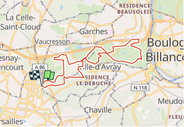

Length
17.7 km

Max alt
184 m

Uphill gradient
288 m
Km-Effort
22 km

Min alt
62 m

Downhill gradient
289 m
Boucle
Yes
Creation date :
2023-05-20 10:21:56.843
Updated on :
2023-05-20 10:23:39.645
4h53
Difficulty : Medium

FREE GPS app for hiking
 SityTrail
IGN / Geographical institutes
SityTrail Plus
The world is yours!
About
Trail Walking of 17.7 km to be discovered at Ile-de-France, Hauts-de-Seine, Ville-d'Avray. This trail is proposed by Rando MLC.
Positioning
Country:
France
Region :
Ile-de-France
Department/Province :
Hauts-de-Seine
Municipality :
Ville-d'Avray
Location:
Unknown
Start:(Dec)
Start:(UTM)
437681 ; 5407680 (31U) N.
Comments