


le Lirou

ARVIEU
User
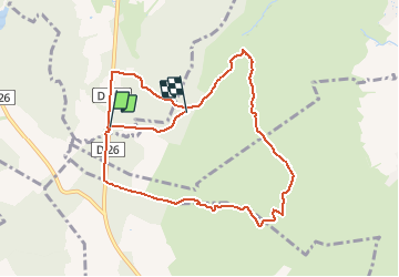

Length
10 km

Max alt
206 m

Uphill gradient
185 m
Km-Effort
12.4 km

Min alt
127 m

Downhill gradient
147 m
Boucle
No
Creation date :
2014-12-10 00:00:00.0
Updated on :
2014-12-10 00:00:00.0
2h21
Difficulty : Easy

FREE GPS app for hiking
 SityTrail
IGN / Geographical institutes
SityTrail Plus
The world is yours!
About
Trail Walking of 10 km to be discovered at Occitania, Hérault, Sainte-Croix-de-Quintillargues. This trail is proposed by ARVIEU.
Description
le lirou
Positioning
Country:
France
Region :
Occitania
Department/Province :
Hérault
Municipality :
Sainte-Croix-de-Quintillargues
Location:
Unknown
Start:(Dec)
Start:(UTM)
573048 ; 4844818 (31T) N.
Comments
Belle rando dans la garrigue. Dommage que la trace fasse cette boucle inutile qui ne vous ramène pas au départ