


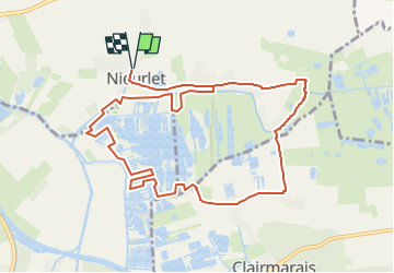
Etang de Romelaere

Jamyfredo
User

Length
10.7 km

Max alt
11 m

Uphill gradient
39 m
Km-Effort
11.2 km

Min alt
-2 m

Downhill gradient
39 m
Boucle
Yes
Creation date :
2023-05-21 07:37:26.281
Updated on :
2023-05-21 07:39:32.311
2h33
Difficulty : Easy

FREE GPS app for hiking
 SityTrail
IGN / Geographical institutes
SityTrail Plus
The world is yours!
About
Trail Walking of 10.7 km to be discovered at Hauts-de-France, Nord, Nieurlet. This trail is proposed by Jamyfredo.
Description
Promenade paisible autour des étangs
Positioning
Country:
France
Region :
Hauts-de-France
Department/Province :
Nord
Municipality :
Nieurlet
Location:
Unknown
Start:(Dec)
Start:(UTM)
449374 ; 5626675 (31U) N.
Comments