


canal de Marseille

darranger
User
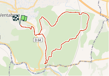

Length
12.3 km

Max alt
247 m

Uphill gradient
205 m
Km-Effort
15 km

Min alt
157 m

Downhill gradient
205 m
Boucle
Yes
Creation date :
2023-05-21 09:24:12.053
Updated on :
2023-05-21 14:57:23.728
3h14
Difficulty : Difficult

FREE GPS app for hiking
 SityTrail
IGN / Geographical institutes
SityTrail Plus
The world is yours!
About
Trail Walking of 12.3 km to be discovered at Provence-Alpes-Côte d'Azur, Bouches-du-Rhône, Ventabren. This trail is proposed by darranger.
Positioning
Country:
France
Region :
Provence-Alpes-Côte d'Azur
Department/Province :
Bouches-du-Rhône
Municipality :
Ventabren
Location:
Unknown
Start:(Dec)
Start:(UTM)
685737 ; 4822733 (31T) N.
Comments