


Combovin

meillon
User
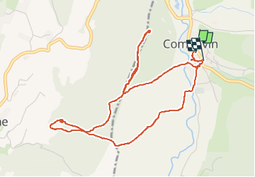

Length
5.9 km

Max alt
530 m

Uphill gradient
224 m
Km-Effort
8.9 km

Min alt
359 m

Downhill gradient
219 m
Boucle
Yes
Creation date :
2023-05-21 13:16:42.03
Updated on :
2023-05-21 15:55:54.448
2h38
Difficulty : Medium

FREE GPS app for hiking
 SityTrail
IGN / Geographical institutes
SityTrail Plus
The world is yours!
About
Trail Walking of 5.9 km to be discovered at Auvergne-Rhône-Alpes, Drôme, Combovin. This trail is proposed by meillon.
Description
montée au château ( une tour carrée), puis vers la chapelle Sainte Marguerite. Point de vue panoramique sur l Ardèche. parcours parfois dru en descente mais très intéressant.
Positioning
Country:
France
Region :
Auvergne-Rhône-Alpes
Department/Province :
Drôme
Municipality :
Combovin
Location:
Unknown
Start:(Dec)
Start:(UTM)
664078 ; 4971118 (31T) N.
Comments