


SityTrail - 771882 - sentier-de-lxarmangex

bubuserge
User
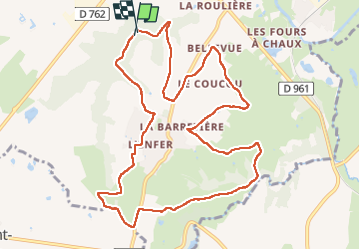

Length
11.7 km

Max alt
91 m

Uphill gradient
193 m
Km-Effort
14.3 km

Min alt
21 m

Downhill gradient
195 m
Boucle
Yes
Creation date :
2023-05-21 18:53:32.624
Updated on :
2023-05-21 18:54:46.661
3h15
Difficulty : Difficult

FREE GPS app for hiking
 SityTrail
IGN / Geographical institutes
SityTrail Plus
The world is yours!
About
Trail Walking of 11.7 km to be discovered at Pays de la Loire, Maine-et-Loire, Chalonnes-sur-Loire. This trail is proposed by bubuserge.
Description
entre vignobles et sous bois
Positioning
Country:
France
Region :
Pays de la Loire
Department/Province :
Maine-et-Loire
Municipality :
Chalonnes-sur-Loire
Location:
Unknown
Start:(Dec)
Start:(UTM)
668110 ; 5245383 (30T) N.
Comments
super Randonnée !