


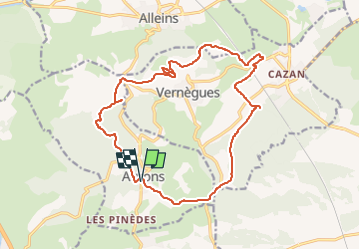
Aurons - Vernègues

ARPF
User

Length
19.1 km

Max alt
387 m

Uphill gradient
438 m
Km-Effort
25 km

Min alt
171 m

Downhill gradient
438 m
Boucle
Yes
Creation date :
2023-05-22 06:28:57.001
Updated on :
2023-05-22 06:32:34.125
5h39
Difficulty : Medium

FREE GPS app for hiking
 SityTrail
IGN / Geographical institutes
SityTrail Plus
The world is yours!
About
Trail Walking of 19.1 km to be discovered at Provence-Alpes-Côte d'Azur, Bouches-du-Rhône, Aurons. This trail is proposed by ARPF.
Positioning
Country:
France
Region :
Provence-Alpes-Côte d'Azur
Department/Province :
Bouches-du-Rhône
Municipality :
Aurons
Location:
Unknown
Start:(Dec)
Start:(UTM)
673858 ; 4836782 (31T) N.
Comments