


Talbert BS

bstebe
User
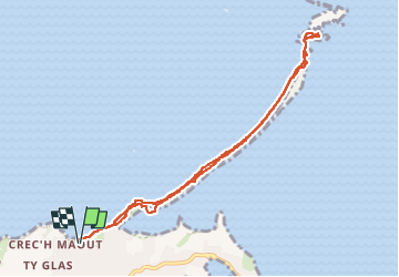

Length
8.4 km

Max alt
8 m

Uphill gradient
23 m
Km-Effort
8.7 km

Min alt
-1 m

Downhill gradient
24 m
Boucle
Yes
Creation date :
2023-05-22 10:11:23.057
Updated on :
2023-05-22 13:05:19.972
2h53
Difficulty : Medium

FREE GPS app for hiking
 SityTrail
IGN / Geographical institutes
SityTrail Plus
The world is yours!
About
Trail Walking of 8.4 km to be discovered at Brittany, Côtes-d'Armor, Pleubian. This trail is proposed by bstebe.
Positioning
Country:
France
Region :
Brittany
Department/Province :
Côtes-d'Armor
Municipality :
Pleubian
Location:
Unknown
Start:(Dec)
Start:(UTM)
492122 ; 5412468 (30U) N.
Comments